 Catalogue PIGMA
Ifremer / CERSAT
Type of resources
Topics
Keywords
Contact for the resource
Provided by
Years
Formats
Representation types
status
Resolution
-
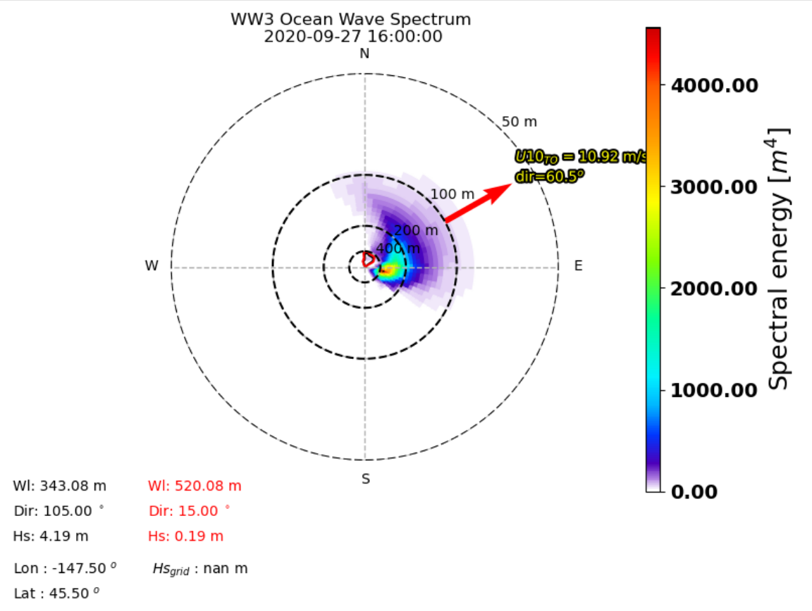
The Ifremer Wind and Wave Operation Center (IWWOC) runs daily the WaveWatch III (WW3) model to provide surface wave colocations with both SCAT and SWIM instruments onboard CFOSAT. CFOSAT (Chinese French Ocean SATellite) is a french-chinese mission launched in 2018, whose aim is to provide wind (SCAT instrument) and wave (SWIM instrument) measurements over the sea surface. Directional wave spectra are calculated over SWIM sensing geometries over each measurement, thanks to the dedicated toolbox (WAVERUN) which was developed by IFREMER for the colocation of WW3 and satellite remote sensing products. The current Ifremer WW3 run is global, hourly and at 0.25° spatial resolution. Two different colocation product are generated: - WW3 with CWWIC L2 provides WW3 directional spectra over the CWWIC SWIM L2 geometry, meaning a colocated valid is provided for each box defined in CWWIC L2 product. - WW3 with IWWOC L2S provides a WW3 directional spectra over IWWOC SWI_L2S__ product. For each of these products, a colocation product is provided respetively for each input file from CWWIC SWI_L2___ and IWWOC SWI_L2S (for each incidence in the later one). It contains the modelled spectral density and all forcing fields: current, wind, friction velocity, air sea temperature difference. Other parameters can be added in the future. The SWIM and WW3 colocation product is generated and distributed by Ifremer / CERSAT in the frame of the Ifremer Wind and Wave Operation Center (IWWOC) co-funded by Ifremer and CNES and dedicated to the processing of the delayed mode data of CFOSAT mission. Note: colocations with SCAT instrument onboard CFOSAT are also within the SWISCA L2S product also available at IWWOC. It provides WW3 directional spectra over SCAT L2A geometry, meaning a model value is calculated for each Wind Vector Cell (WVC) of L2A/L2B types of SCAT product.
-
The SWISCA Level 2S (L2S) product provides along-track colocation of SWIM wave measuring instrument onto SCAT scatterometer grid, over the global ocean. SWIM and SCAT are both instruments onboard CFOSAT. CFOSAT (Chinese French Ocean SATellite) is a french-chinese mission launched in 2018, whose aim is to provide wind (SCAT instrument) and wave (SWIM instrument) measurements over the sea surface. The SWISCA L2S product is broken down into three different subproducts: - L2A containing the sigma0 of both SWIM and SCAT - L2B containing the wave parameters measured by SWIM and wind vectors measured by SCAT - AUX containing additional ancillary fields such as sea ice concentration (from CERSAT/SSMI), ocean currents (from CMEMS/GlobCurrent), SST and Wind (from ECMWF), rain rate (from IMERG), and WaveWatch3 wave spectra. All SWIM and ancillary observations are resampled onto SCAT scatterometer's geometry (wind vector cells, WVC). The SWISCA level 2S product is generated in delayed mode, a few days after acquisition. It is intended to foster cross analysis of SWIM and SCAT observations, and their combination to improve the retrieval of both wind and wave parameters. The SWISCA L2S product is generated and distributed by Ifremer / CERSAT in the frame of the Ifremer Wind and Wave Operation Center (IWWOC) co-funded by Ifremer and CNES and dedicated to the processing of the delayed mode data of CFOSAT mission.
-
The SMOS Level 3 Sea Ice Thickness product, in NetCDF format, provides daily estimations of SMOS-retrieved sea ice thickness (and its uncertainty) at the edge of the Arctic Ocean during the October-April (winter) season, from year 2010 onwards. The sea ice thickness is retrieved from the SMOS L1C product, up to a depth of approximately 0.5-1 m, depending on the ice temperature and salinity. Daily maps, projected on polar stereographic grid of 12.5 km, are generated by the Alfred Wegener Institut (AWI). This product is complementary with sea ice thickness measurements from ESA's CryoSat and Copernicus Sentinel-3 missions.
-
Satellite altimeters routinely supply sea surface height (SSH) measurements which are key observations to monitor ocean dynamics. However, below a wavelength of about 70 km, along-track altimeter measurements are often characterized by a dramatic drop in the signal-to-noise ratio, making it very challenging to fully exploit available altimeter observations to precisely analyze small mesoscale variations in SSH. Although various approaches have been proposed and applied to identify and filter noise from measurements, no distinctive methodology emerged to be systematically applied in operational products. To best cope with this unresolved issue, the Copernicus Marine Environment Monitoring Service (CMEMS) actually provides simple band-pass filtered data to mitigate noise contamination in the along-track SSH signals and more innovative and adapted noise filtering methods are thus left to users seeking to unveil small-scale altimeter signals. Here demonstrated, a fully data-driven approach is developed and applied to provide robust estimates of noise-free Sea Level Anomaly (SLA) signals. The method combines Empirical Mode Decomposition (EMD), to help analyze non-stationary and non-linear processes, and an adaptive noise filtering technique inspired by Discrete Wavelet Transform (DWT) decompositions. It is now found to best resolve the distribution of the sea surface height variability in the mesoscale 30-120 km wavelength band. A practical uncertainty variable is attached to the denoised SLA estimates that accounts for errors related to the local signal to noise ratio, but also for uncertainties in the denoising process, which assumes that SLA variability results in part from a stochastic process. Here, measurements from the Jason-3, Sentinel-3 A and SARAL/AltiKa altimeters are processed and analyzed, and their energy spectral and seasonal distributions characterized in the small mesoscale domain. Anticipating data from the upcoming Surface Water and Ocean Topography (SWOT) mission, these denoised SLA measurements for three reference altimeter missions already yield valuable opportunities to assess global small mesoscale kinetic energy distributions. This dataset was developed within the Ocean Surface Topography Science Team (OSTST) activities. A grant was awarded to the SASSA (Satellite Altimeter Short-scale Signals Analysis) project by the TOSCA board in the framework of the CNES/EUMETSAT call CNES-DSP/OT 12-2118. Altimeter data were provided by the Copernicus Marine Environment Monitoring Service (CMEMS) and by the Sea State Climate Change Initiative (CCI) project.
-
This dataset provides detections of fronts derived from high resolution remote sensing SST observations by SEVIRI L3C from OSISAF over Western Europe region. The data are available through HTTP and FTP; access to the data is free and open. In order to be informed about changes and to help us keep track of data usage, we encourage users to register at: https://forms.ifremer.fr/lops-siam/access-to-esa-world-ocean-circulation-project-data/ This dataset was generated by OceanDataLab and is distributed by Ifremer / CERSAT in the frame of the World Ocean Circulation (WOC) project funded by the European Space Agency (ESA).
-
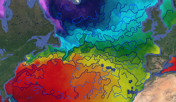
This dataset provides detections of fronts derived from low resolution optimally interpolated remote sensing microwave SST L4 from REMSS over North Atlantic region. The data are available through HTTP and FTP; access to the data is free and open. In order to be informed about changes and to help us keep track of data usage, we encourage users to register at: https://forms.ifremer.fr/lops-siam/access-to-esa-world-ocean-circulation-project-data/ This dataset was generated by OceanDataLab and is distributed by Ifremer / CERSAT in the frame of the World Ocean Circulation (WOC) project funded by the European Space Agency (ESA).
-
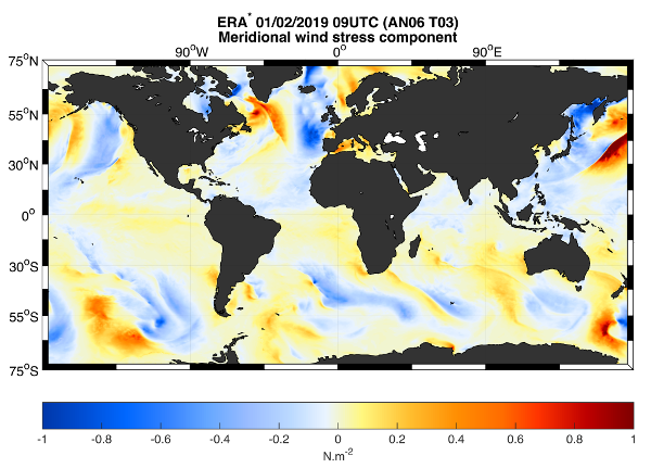
This dataset provides the meridional and zonal components of both the stress-equivalent wind (U10S) and wind stress (Tau) vectors. The ERA* product is a correction of the ECMWF Fifth Reanalysis (ERA5) output by means of geo-located scatterometer-ERA5 differences over a 15-day temporal window. The product also contains ERA5 U10S and Tau. The data are available through HTTP and FTP; access to the data is free and open. In order to be informed about changes and to help us keep track of data usage, we encourage users to register at: https://forms.ifremer.fr/lops-siam/access-to-esa-world-ocean-circulation-project-data/ This dataset was generated by ICM (Institute of Marine Sciences) / CSIC (Consejo Superior de Investigaciones Científicas) and is distributed by Ifremer / CERSAT in the frame of the World Ocean Circulation (WOC) project funded by the European Space Agency (ESA).
-
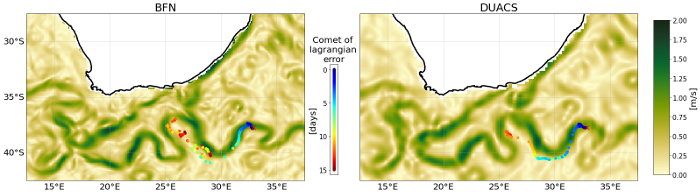
This dataset provides Level 4 total current including geostrophy and a data-driven approach for Ekman and near-inertial current, based on a convolution between drifter observation and wind history, to fit empirically a complex and time-lag dependant transfert function between ERA5 wind stress and current The data are available through HTTP and FTP; access to the data is free and open. In order to be informed about changes and to help us keep track of data usage, we encourage users to register at: https://forms.ifremer.fr/lops-siam/access-to-esa-world-ocean-circulation-project-data/ This dataset was generated by Datlas and is distributed by Ifremer / CERSAT in the frame of the World Ocean Circulation (WOC) project funded by the European Space Agency (ESA).